Geographic information systems (GIS) and computer-aided design and drafting (CADD) software function as separate systems, each with unique capabilities to visually communicate spatial or design information. The opportunity to integrate GIS and CADD data is commonly overlooked because it can be a tedious process requiring considerable planning to define workflows and data standards. However, CADD/GIS integration is a powerful way to synthesize information, resulting in improved project planning, implementation, and outcomes.
In its simplest form, a CADD drawing is assigned a coordinate system and the drawing objects correspond to real-world locations, enabling the CADD drawing to be used in GIS. Integration also allows data originating in GIS to contribute to the CADD design. The synergies created by integrating CADD and GIS data offer numerous project advantages, including the five benefits detailed below.
1. Spatial Analysis
CADD objects may include dimensions, lines, and circles, among other graphic elements. However, CADD software cannot perform spatial analyses, which can show how a design may interact with, or impact, its surroundings when implemented in the real world, and conversely, how the world may impact a design. Integrating CADD models into GIS provides a geographic framework for the design, creating opportunities to use the assortment of spatial analysis tools GIS offers. Such analyses benefit decision-making processes and improve overall project efficiency from the planning phase to completion. For example, performing proximity analyses early in a project may help determine if a proposed well location is an appropriate distance from a water body prior to drilling.
2. Project Setting
Incorporating GIS data and CADD designs can help identify areas where a project’s design may interfere with existing surface and subsurface infrastructure or landscape features. GIS data provides the context for CADD design. By assessing how a project fits within the larger landscape, potential conflicts can be identified and resolved in the planning phase, saving time and money.
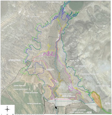
Figure 1. This CADD drawing integrates aerial imagery from GIS with the design data. On its own, the CADD drawing helps viewers understand the surrounding area, but is enhanced by the real-world context provided by GIS data. The integration is an improvement over what each software can achieve on its own. This example illustrates a lower level of integration. Additional benefits are realized as greater levels of integration are achieved (see Figure 2).
3. Stakeholder Visualization
Integrating GIS and CADD information can provide increased transparency by generating a more realistic, comprehensive visual and spatial model. Visualization allows stakeholders to better understand the result, leading to improved community buy-in, more engagement at planning meetings, and less time spent trying to convey what the project will deliver.
4. 3D Analysis
In addition to using GIS to give spatial reference to CADD objects and the perks that come along with that, GIS is a useful tool to visualize surfaces in 3D. Three-dimensional representations of Digital Elevation Models (DEMs) make compelling and realistic base maps for CADD designs and geospatial data. Many analyses can be performed on DEMs in GIS, including terrain analysis (slope calculation) and hydrologic modeling. In some cases, DEMs can be suitable for use in CADD to answer questions such as, “Is the amount of earthwork required for this project greater than we can feasibly do?”
5. Integration Tools
While CADD and GIS data may function with a degree of interoperability wherein data can be transferred between the programs and then modified, this approach has its limitations and commonly leads to data redundancy. With true integration, any newly generated data are part of an all-encompassing, official database, regardless of the software used to generate it. Integrating CADD and GIS data prevents dataset redundancy and allows GIS and CADD users to incorporate data into either program interchangeably, streamlining project workflows.
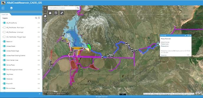
Figure 2. This is an example of higher-level integration. The CADD data shown here are hosted within GIS, available via an internal website, and are used in the field for landowner coordination and field data collection. The same data are used by both CADD and GIS, allowing both platforms to benefit from a single source of truth.
Uniting CADD’s design functionality with GIS’s spatial datasets allows users and clients to better conceptualize a project from start to finish. A cohesive package of GIS and CADD data can provide enhanced analysis and visualization to promote efficient planning, decision-making, and execution of project tasks.
Questions? Connect with us!